 |
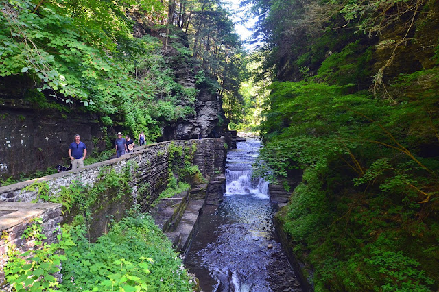
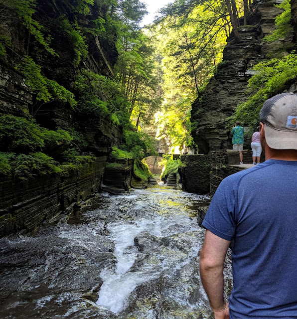
| Views along the Gorge Trail |
It sort of became a new tradition to explore New York on the fourth of July. It all started last year when I convinced my parents we should spend the long weekend up in the Ausable area, camping, exploring, and hiking up in the gorgeous Adirondacks. It was a great trip that included one of my favorite hikes to date, Indian Head. Since then, I have made it a mission to spend more time exploring this huge state of New York that is truly an outdoor lover's paradise. I've done a few hikes in the Catskills, spent some time in the Adirondacks and now, spent the fourth of July holiday in the Finger Lakes.
Spending America's birthday deep in the woods and in one of our countries state parks is my favorite way to celebrate Independence Day.
Spending America's birthday deep in the woods and in one of our countries state parks is my favorite way to celebrate Independence Day.

Finger Lakes Region of New York
The transition is startling and the Finger Lakes region of New York is a sight you just have to see for yourself.

Waterfalls along the Gorge Trail
I didn't.
Not until I started doing some research on some of the best parks and hikes in the Finger Lakes. Once I started googling I was a little stunned that these insanely beautiful places existed, places I had never even heard of. Watkins Glen gets a lot of publicity when it comes to the Finger Lakes and it was a name I had heard of. However, the main trail is not dog-friendly and I had Olive for the weekend. But Robert H. Treman State Park? A new-to-me- name that seems to look a whole lot like Watkins Glen BUT it allows dogs and has the swimming pool (with a diving board).
 |
| Robert H. Treman State Park Map |

Robert H. Treman owned the land before he generously donated it to make Enfield Glen State Park in 1920. When Mr. Treman died in 1937, the park was renamed in his honor. Down by the waterfall/swimming hole, you can still see signage honoring the original name, Enfield Glen.

To see these waterfalls, you can follow the Gorge Trail 2.25 mi (rated strenuous/difficult, I would rate it medium myself. This trail follows the edge of the stream, allowing insanely gorgeous views of this beautiful glen. You can retrace your steps or return on the Rim Trail 2.25 mi (also rated strenuous/difficult, again, medium) which takes you higher above the stream and into the woods as you make your way back to the trailhead. We did the loop at 5.5-miles, leaving from the quieter upper park entrance, hiking to the waterfall/pool at the lower park entrance which is MUCH more crowded, stopping for a swim at the lower waterfall, and heading back along the Rim Trail for a bit before merging back on to the more scenic Gorge Trail which ended where we started

 Trailhead/Trail: Upper Park Entrance along the Gorge Trail to the Lower Park Entrance/Lucifer Falls swimming area, back along the Rim Trail. I recommend starting at the quiet Upper Park Entrance. If you want to swim first or at the end, start at the Lower Park Entrance.
Distance: 5.5 to 6 miles RT - Gorge Trail 2.25 miles and return via the Rim Trail 2.25 miles
Elevation: 820'
** with a few detours and leaving Strava running for a few minutes on our way out, our hike totaled just under 6-miles with about 1,000' of elevation gained
Dogs: Yes! On-leash only
Kids: Older, the trail has some steeper pitches and is a bit long for kids as a round-trip hike. You could also park at the lower park entrance, hike a bit, and trace your steps back to swim in the lower falls pool.
These trail maps were posted along the trail and I was quickly obsessed with them. These placards were small in size, natural colors, and were very descriptive. The little human icon was on a different spot on each of the placards, showing your progress on the trail, mileage remaining, and what the elevation would be.
Genius, right?
We were like little kids when we reached the end of the gorge trail to see this beautiful waterfall and swimming area. After a hot day, this was the perfect way to cool off for a bit. We packed out swimsuits in and there is a changing area right by the natural pool. We each took a turn on the diving board before changing back into hiking gear and heading back along the Rim Trail. The swimming area is open weather and water conditions dependent from 11am to 6pm. We caught it right as it opened and were happy to have some time in the pool before the crowds came in on the Fourth of July.
While Watkins Glen gets all the fame, Robert H. Treman has less crowds and the trails are all dog-friendly. Don't forget your swimsuit as you can end your hike in the swimming pool at the bottom of a waterfall. This was our first hike and first full day in the Finger Lakes and this park set the bar high.
Happy Hiking - and Swimming - and playing in the waterfalls.
 |
| Beginning of the Gorge Trail |

The gorge itself is called Enfield Glen and I was starting to get really confused as I saw signs for glens and gorges that look a lot like ravines. And so, this hike triggered the google search of "what the heck is the difference in a gorge, ravine, gullies, canyon, or glen"?
Gulch: deep V-shaped valley formed by erosion. It may contain a small stream or dry creek bed and is usually larger in size than a gully. Occasionally, sudden intense rainfall may produce flash floods in the area of the gulch.
Valley: a depression with predominant extent in one direction. A very deep river valley may be called a canyon or gorge.
Canyon or Gorge: a deep valley between cliffs often carved from the landscape by a river. The word canyon is generally used in the United States, while the word gorge is more common in Europe and Oceania.
Glen: a valley, typically one that is long and bounded by gently sloped concave sides, unlike a ravine, which is deep and bounded by steep slopes.
Ravine: a very small valley, which is often the product of streamcutting erosion. Often found in urban areas, ravines are typically classified as larger in scale than gullies, although smaller than valleys.

Waterfalls along the Gorge Trail
I won't lie, I am still a little confused but I came to accept this was a Glen and I was following the gorge trail. On this hike, you will pass 12 waterfalls including Lucifer Falls, the 115' multi-tiered cascading waterfall and Lower Falls, a waterfall that empties into a stream-fed pool open for swimming.
To see these waterfalls, you can follow the Gorge Trail 2.25 mi (rated strenuous/difficult, I would rate it medium myself. This trail follows the edge of the stream, allowing insanely gorgeous views of this beautiful glen. You can retrace your steps or return on the Rim Trail 2.25 mi (also rated strenuous/difficult, again, medium) which takes you higher above the stream and into the woods as you make your way back to the trailhead. We did the loop at 5.5-miles, leaving from the quieter upper park entrance, hiking to the waterfall/pool at the lower park entrance which is MUCH more crowded, stopping for a swim at the lower waterfall, and heading back along the Rim Trail for a bit before merging back on to the more scenic Gorge Trail which ended where we started
 |
| Waterfalls |
 |
| Link to Map |


Distance: 5.5 to 6 miles RT - Gorge Trail 2.25 miles and return via the Rim Trail 2.25 miles
Elevation: 820'
** with a few detours and leaving Strava running for a few minutes on our way out, our hike totaled just under 6-miles with about 1,000' of elevation gained
Dogs: Yes! On-leash only
Kids: Older, the trail has some steeper pitches and is a bit long for kids as a round-trip hike. You could also park at the lower park entrance, hike a bit, and trace your steps back to swim in the lower falls pool.
 |
| Hiking along the Gorge Trail |
 |
| Hiking along the Gorge Trail |
 |
| Amazing signage along the Gorge Trail |
These trail maps were posted along the trail and I was quickly obsessed with them. These placards were small in size, natural colors, and were very descriptive. The little human icon was on a different spot on each of the placards, showing your progress on the trail, mileage remaining, and what the elevation would be.
Genius, right?
 |
| Beginning of the Gorge Trail |
Along the way, Olive could sneak in the water quick to cool down or to grab a quick drink. Swimming is not allowed in any area except for the swimming area by lower falls. We did cross the river at one point and saw some people relaxing in one part of the slower stream.
 |
| Lower Falls Swimming Area |
 |
| Lower Falls Swimming Area |
 |
| Lower Falls Swimming Area |
Happy Hiking - and Swimming - and playing in the waterfalls.

No comments :
Post a Comment
Let's Chat!